The Hohokam
by Linda M. Gregonis, Archaeological Consultant
from sonorensis, Volume 16, Number 1 (Spring 1996)
Beneath the creosote and cactus around the Desert Museum, battered stones, sharp-edged pieces of rock, stones for grinding, and fragments of pottery can be found. The Hohokam left these artifacts at the site over 600 years ago. Scatters of prehistoric stone
 tools and pottery like these are common in the Tucson Mountains; they number in the hundreds, maybe even the thousands. Most of the sites show no signs of habitation-no houses, no fire pits. So what did the Hohokam do in these mountains?
 The Hohokam lived in villages near the base of the Tucson Mountains, close to sources of water like the Santa Cruz River or Brawley Wash. Near their villages, on floodplains or alluvial slopes, the Hohokam established fields of corn, beans, squash, and cotton. They used every possible space to grow crops, even building small terraces and check dams on hill slopes to collect and divert rainfall runoff toward their fields. On and near the slopes they also stacked up rocks and planted agave and yucca in the piles.
When they weren't tending to their crops, the Hohokam explored and exploited the environment around them. A day's walk into the hills provided the people with many important resources. They hunted bighorn sheep, deer, and other animals there. They made digging sticks of durable ironwood to retrieve tuberous roots and collected leaves and other plant parts for medicines, food, and dyes. In the spring they gathered cholla buds. In early summer, the Hohokam eagerly collected saguaro and prickly pear fruits. Later in the summer, using holes that they formed in bedrock, the Hohokam pounded mesquite beans into flour.
 When they needed material for houses or ramadas, the Hohokam cut ocotillo poles, chopped down mesquite trees, and scavenged saguaro ribs. Occasionally, they traveled to higher mountains-the Catalinas or the Quinlans-to get sturdier woods like juniper, pinyon, even Douglas fir. The Hohokam ventured up canyons to gather acorns and pinyon nuts and to collect leaves of bear grass and sotol for making baskets.
Before they started growing agave extensively (around A.D. 1150 or so), the Hohokam found those plants at higher elevations. After they cut the leaves off, they dug up the bases, or hearts, of the agaves, then slow-roasted the hearts in rock-filled pits. They ate the baked agave on the spot or shaped it into slabs or cakes that were easily carried and stored.
 While their agave cooked, people carefully toasted the agave leaves to make acids contained in them less stringent. Then, using stone or wood scrapers, they defleshed the leaves, exposing long fibers. The Hohokam spun these fibers into yarns for weaving cloth. They also twisted the strands into sturdy rope and twine.
Throughout the mountains, the Hohokam found good rocks for making stone tools. They made tools by striking stone against stone until sharp-edged flakes were released. Then, they fashioned the flakes into knives, scrapers, and arrowheads, leaving the unwanted fragments of rock behind.
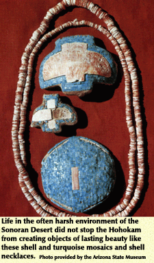
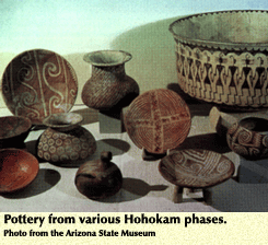
Pottery makers found nodules of hematite in the hills. By crushing and grinding the nodules into powder, then mixing that powder with clay, they created red ocher, which they then used to paint their pots. Other artisans found pieces of red argillite (a clay-like rock) or jasper that they carved into jewelry and other trinkets.
The Hohokam also used the mountains for purposes we don't understand. We do not know the meanings of the petroglyph sites where people pecked lively designs of snakes, lizards, bighorn sheep, and humans onto dark-colored boulders. Nor do we know why they left pieces of pottery and other objects under rocks near the tops of hills. Shrines, perhaps?
The pattern of use seen at sites in and around the Tucson Mountains can be found throughout the Hohokam region, from Phoenix to Green Valley and from Sells and Gila Bend to the San Pedro River. Because of the geological and biological diversity of the Sonoran Desert there are, of course, variations in the pattern. In areas of little water like the Papaguer�a west of Tucson, the Hohokam grew crops, but relied more on wild resources. In the Salt and Gila Valleys, where the rivers flowed year-round, the Hohokam built huge irrigation systems and grew much of their food.
But the canals that made the Hohokam famous in our eyes may have contributed to their downfall. Canals enabled the people to congregate in larger villages. As villages expanded, people had to go farther from the rivers and canals to hunt game and collect wild foods. This made them more dependent on their crops, and they began to suffer from malnutrition. Clearing fields, cutting timber near the rivers, and diverting the waters probably caused changes in the river banks. Weather events in the mid to late A.D. 1300s may have pushed an already precarious system over the edge. At least two large floods occurred on the Salt River, destroying the heads of major canal systems. The canals were not rebuilt. The large villages were abandoned.
By the mid to late 1400s, the Hohokam culture was gone, but the way of life that supported the initial development of the culture, some 900 years before that, remained. We will probably never know for sure if the O'odham are the descendents of the Hohokam. We do know that the O'odham way of living with the desert is remarkably similar to what we find in the archaeological record.